What Is an Atmospheric River? Explained
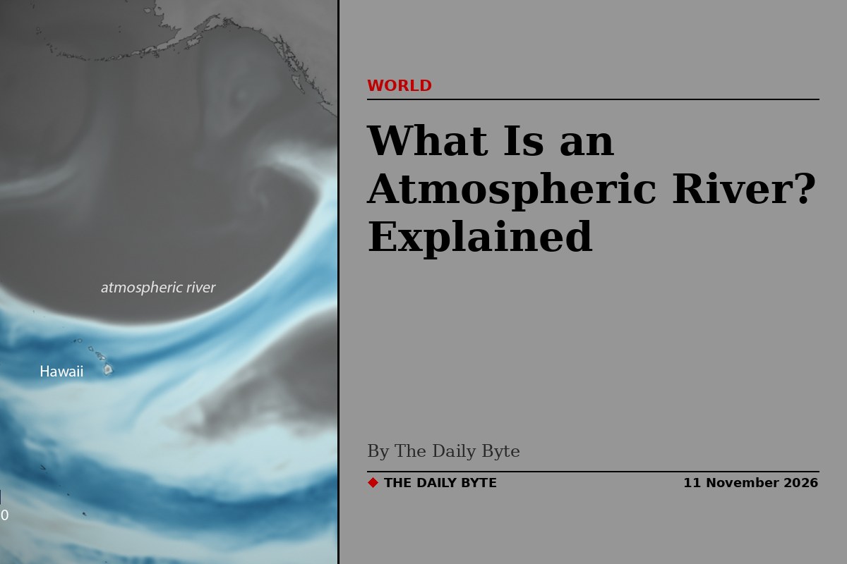
An atmospheric river is a long, narrow band of water vapour moving through the sky: a river in the sky. It picks up moisture from warm tropical oceans, carries it thousands of miles, and drops it as rain or snow when it reaches land. The direct answer is simple. It is not a river of liquid water. It is a moving stream of invisible water vapour that becomes very visible weather when it makes landfall, and it can deliver a month's rain in a few days.
Atmospheric rivers are in the news this week because a series of them is aimed at the west coast of the United States. Forecasters expect heavy rain, mountain snow and strong winds in Washington, Oregon and California between 11 and 15 November, with the risk of flooding in parts of the Pacific Northwest and northern California, and more systems possible into the following week.
How big is an atmospheric river?
Atmospheric rivers are relatively long, narrow regions in the atmosphere that transport most of the water vapour outside of the tropics, according to the National Oceanic and Atmospheric Administration, NOAA. They vary greatly in size and strength, but the average atmospheric river carries an amount of water vapour roughly equivalent to the average flow of water at the mouth of the Mississippi River. Exceptionally strong ones can transport up to 15 times that amount.
To make that comparison, scientists calculate the mass of water vapour in the atmospheric river and divide it by the density of liquid water. The result is a flow rate that can be set beside a real river, and the comparison is startling: a band of sky only a few hundred miles wide can move as much water as one of the world's great rivers. NOAA's satellite service puts the typical width at about 250 to 375 miles, with a length of more than 1,000 miles. Several are active around the world at any given moment: NOAA's Physical Sciences Laboratory estimates that between six and ten are under way across the Earth at any one time.
How does an atmospheric river form?
Atmospheric rivers usually begin over tropical regions. Warm temperatures there cause ocean water to evaporate and rise into the atmosphere, and strong winds then carry that water vapour along, sometimes for thousands of miles. The vapour itself is invisible. It only becomes cloud and rain when the moving air is forced upwards, cools, and the vapour condenses into water droplets.
That lifting happens when the river reaches land. As it moves over the coast and up the slopes of coastal mountains, the water vapour is pushed higher into the atmosphere, cools into droplets and falls as rain or snow. Low-pressure systems often travel along the length of the river, adding energy that turns vapour into rain and snow more rapidly, and in some cases those systems strengthen quickly into powerful storms. When the river stalls over one watershed, the rain keeps falling on the same place, which is when flooding begins.
What is the Pineapple Express?
The Pineapple Express is the best-known kind of atmospheric river. It is a strong atmospheric river that picks up warm, moist air near Hawaii and carries it across the Pacific to the west coast of the United States and Canada. It gets its name from Hawaii, where pineapples grow, and from the speed with which the moisture arrives.
When the Pineapple Express hits land in the western United States and Canada, it can cause heavy rain and snow. In California it can produce up to five inches of rain in a single day, according to NOAA's satellite service. Not every atmospheric river is a Pineapple Express: the name belongs only to the ones that draw their moisture from the tropical Pacific around Hawaii. Other atmospheric rivers form over other oceans and affect other coasts, but the Hawaii-to-California route is the one that has become famous, because it so often brings both the water California needs and the floods it fears.
Are atmospheric rivers good or bad?
The honest answer is both, and that is what makes them so important. Most atmospheric rivers are weak systems that bring beneficial rain or snow, and they are a key feature in the global water cycle. A few events each year cause up to half of the annual precipitation on the US West Coast, and the precipitation they deliver provides roughly 30 to 50 per cent of the region's annual water supply. Without them, the reservoirs and snowpack that California, Oregon and Washington depend on would run far lower.
The danger comes from the strongest ones, especially when they stall. Those that contain the largest amounts of water vapour and the strongest winds can create extreme rainfall and floods, often by parking over watersheds that are vulnerable to flooding. NOAA warns that these events can disrupt travel, cause mudslides and cause catastrophic damage to life and property.
History gives a clear example. A series of atmospheric rivers fuelled the strong winter storms that battered the US West Coast from western Washington to southern California from 10 to 22 December 2010, producing 11 to 25 inches of rain in certain areas. The same rivers also built up the snowpack in the Sierra Nevada, which had received 75 per cent of its annual snow by 22 December, the first full day of winter. The same system that fills the reservoirs can flood the valleys below them.
How are atmospheric rivers ranked?
In 2019, NOAA and the Scripps Institution of Oceanography introduced a five-category scale for atmospheric rivers, similar in idea to the Saffir-Simpson scale used for hurricanes. The scale, set out by Ralph and colleagues in the Bulletin of the American Meteorological Society, ranks events by their strength and duration. Category 1 events are primarily beneficial, bringing useful rain and snow. Category 5 events are primarily hazardous, with the potential for severe flooding and damage. The categories in between are judged on the balance between the water they deliver and the harm they cause, which is why forecasters describe an incoming system by its category as well as by how much rain it is expected to drop.
What is happening on the US West Coast this week?
The current spell is not a single storm but a sequence. Researchers at the Center for Western Weather and Water Extremes at the University of California San Diego identified four atmospheric-river episodes affecting the Pacific Northwest between 5 and 12 November. Their assessment showed the third system arriving around 9 November, followed by a fourth beginning on 10 November, with an 80 to 90 per cent probability of atmospheric-river conditions across parts of the Pacific Northwest between 9 and 12 November.
NOAA's Weather Prediction Center forecast between three and seven inches of precipitation across the Olympic Peninsula and the Cascades during the 72 hours ending early on 12 November, with 1.5 to 2.5 inches in the Klamath Mountains and around half an inch to 1.5 inches across broader coastal areas of Washington, Oregon and northern California. Looking further ahead, NOAA's Climate Prediction Center put a moderate risk, meaning a 40 to 60 per cent chance, of heavy precipitation across parts of the Pacific Northwest and northern and central California from 13 to 15 November, along with a moderate risk of heavy snow at high elevations in the Klamath and Sierra Nevada mountains, where forecasters said multi-foot snow totals were possible. The same outlook gave a slight risk, 20 to 40 per cent, of heavy precipitation extending to 17 November along the whole West Coast.
A very strong El Nino is helping to set the backdrop, lining up a series of storms in the North Pacific that is sending rain and waves towards the West Coast through November. Exact storm tracks are still shifting, which is why the Climate Prediction Center has held the risk at moderate rather than raising it to high, but the message from forecasters is consistent: the West Coast should expect a wet and windy spell, with the heaviest rain and snow falling between 11 and 15 November.
How do forecasters track atmospheric rivers?
Because an atmospheric river is made of water vapour, it cannot be seen from the ground until it starts raining. Forecasters rely on satellites. NOAA's GOES West weather satellite captures images and information about the amount and location of moisture in the atmosphere on the West Coast as often as every five minutes, which lets forecasters watch the river approach and judge where it will make landfall.
That monitoring is combined with radar, aircraft observations and weather models. NOAA says its research has helped forecasters issue warnings for potential heavy rain and flooding in areas prone to atmospheric-river impacts as many as five to seven days in advance. That lead time matters: it is what allows reservoir managers to release water before a storm, emergency services to prepare for floods and mudslides, and residents to know whether the rain heading their way is an ordinary winter storm or something much larger.
Frequently asked questions about atmospheric rivers
Is an atmospheric river a hurricane? No. A hurricane is a rotating tropical storm with an eye and a warm core. An atmospheric river is a band of moisture carried along by the winds, usually attached to an ordinary mid-latitude storm system. It has no eye and does not spin, but it can make the storm it travels with far wetter than it would otherwise be.
Is the Pineapple Express the same thing as an atmospheric river? No. The Pineapple Express is one specific type of atmospheric river, the one that runs from the warm waters near Hawaii to the US West Coast. Atmospheric rivers form over many oceans and affect many coasts, but only the Hawaii route carries that nickname.
Can an atmospheric river bring snow as well as rain? Yes. At low elevations it falls as rain, but in the mountains the same moisture falls as snow, often in large amounts. Forecasters expect heavy snow at high elevations in the Klamath and Sierra Nevada mountains during this week's event, with the possibility of several feet of snow in places.
How much rain can one atmospheric river bring? A Pineapple Express can drop up to five inches of rain on California in a single day. The series of atmospheric rivers that hit the West Coast in December 2010 produced 11 to 25 inches of rain in certain areas over twelve days. The heaviest totals come when the river stalls over the same watershed.
Why are they called rivers if there is no liquid water? Because of the sheer volume of water they move. An average atmospheric river transports water vapour at a rate comparable to the flow of the Mississippi at its mouth, and the strongest can carry up to 15 times that amount. The name describes the flow, not the form the water takes while it is still in the sky.